


Come to Viseu! Come to Maramures!
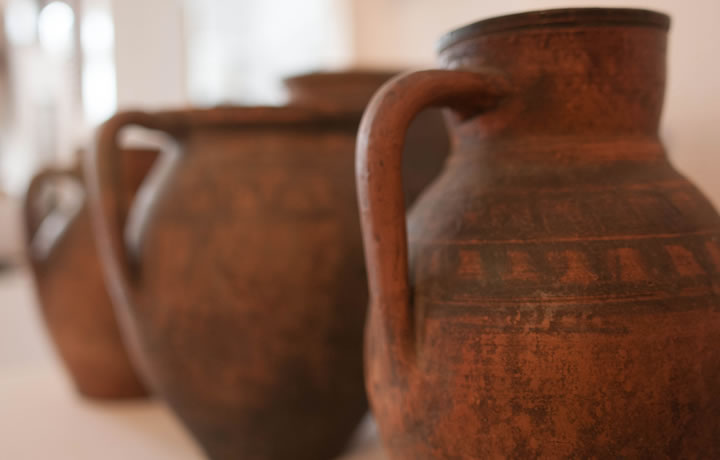
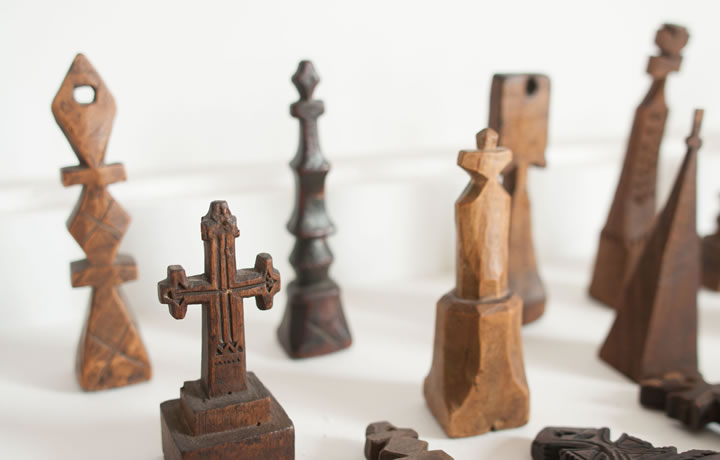
Located in the Northern part of Transylvania, next to the Ukrainian border, Maramures is a county known for both its traditional valences: conservation of traditions and customs, wood carving, traditional clothing and UNESCO monument churches, and its numerous natural objectives: high mountains covered with Europe’s last virgin forests, mild hills and valleys hosting traditional settlements, a land filled with protected natural areas, a land of spectacular beauty and natural diversity.
Having a favorable position, being accessible by almost all transportation modes, but safe enough from "the modern civilization" to keep its authenticity, traditionalism and natural beauty, far from the trodden roads, the County of Maramures is an invitation to an authentic touristic experience, close to the land’s people and their way of life.
Positioning
The County of Maramures is located in the Northern part of Romania, in Transylvania, by the border with Ukraine. The county spreads between the 47º20'00" and 48º00'15" Northen Latitude parallels and the 22º52'30" and 25º07'30" Eastern longitude meridians, over a distance of 160 km between its most Eastern and Western points and 60 km from North to South, thus having a longitudinally elongated shape.
The county’s neighbors are:
The county’s neighbors are:
- North: Ukraine
- East: Suceava county
- South: Bistriţa - Năsăud and Sălaj county
- West: Satu Mare county

Access
Even if it is not situated on the major transportation routes, the County of Maramures is quite accessible by almost all means of transportation, namely by road, by rail and by air.
- Access by road: The main access route to Maramures is the E58 European Road that crosses the county from South to West, between Cluj and Satu Mare county. Also, the access within the county is ensured by the network of national roads: DN 18 Baia Mare – Sighetu Marmaţiei – Vişeu de Sus – Borşa and DN 18B Baia Mare – Târgu Lăpuş – Căşeiu (junction point with E58 in the Cluj county), county roads and communal roads.
www.flixbus.ro/curse
- Access by rail: The railway access to the county is ensured by the CFR trains, on the 400, 401, 409 and 410 thoroughfares, which link the big cities of the county (Baia Mare, Vişeu de Sus, Sighetu Marmaţiei, Borşa) and the villages located on the way to interest points from Satu Mare, Sălaj, Cluj şi Bistriţa Năsăud.
- Access by air: The County of Maramures is accessible by air through Baia Mare International Airport, which currently operates flights only to and from Bucuresti- Otopeni Airport, or through Cluj Napoca International Airport that operates both internal and international flights, and then through E58 road.
Map
Geography
Located in the Northern part of the country, neighboring the Satu Mare, Salaj, Cluj, Bistrita-Nasaud and Suceava counties and Ukraine on a distance of 154 km, the County of Maramures has an area of 6,304 sq km and a population of 478,659 persons according to the 2011 census.
Regarding its relief, Maramures is mostly a hill and mountain county, even if the lowest areas of depressions go down to 135 m on the Somes at Seini and to 204 m on Tisa at Piatra. The relief, despite its variety, is dominated by the mountain chains belonging to the Oriental Carpathian Mountains: the Rodna mountains, the Maramures mountains and the Gutâi – Lăpuş – Ţibleş volcanic mountains, by the Maramures and Baia Mare depressions and by the Codrului peak and the Preluca and Dealu Mare massifs.
 The Rodna mountains are the most massive and high mountains from the entire Oriental Carpathian chain, and are represented in the County of Maramures by the northern slope, between the Prislop 1416 m and the Setref 823 m passes, with several summits that exceed 2000 m: Pietrosu 2003 m, Rebra 2119 m. Almost the entire northern slope is included in the Rodna Mountains National Park, which has a typical landscape marked by the ice-ages: glacial ridges, steeps, circuses, thresholds and valleys.
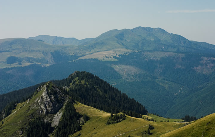 The Maramures Mountains lay over app. 100 kms from the junction on Viseu and Tisa rivers to the Prislop Pass where they join the Rodna Mountains. The mountains are fragmented in several massifs, limited by valleys, the most important ones being Pop Ivan 1937 m, Farcău 1957 m, Toroioaga 1930 m and Cearcănu 1847 m. These mountains make up the Maramures Mountains National Park, together with a part of the Maramures depression.
Regarding its relief, Maramures is mostly a hill and mountain county, even if the lowest areas of depressions go down to 135 m on the Somes at Seini and to 204 m on Tisa at Piatra. The relief, despite its variety, is dominated by the mountain chains belonging to the Oriental Carpathian Mountains: the Rodna mountains, the Maramures mountains and the Gutâi – Lăpuş – Ţibleş volcanic mountains, by the Maramures and Baia Mare depressions and by the Codrului peak and the Preluca and Dealu Mare massifs.
The Gutai – Lapus – Tibles volcanic mountains lay over from N-V to S-E, are made up of eruptive and sedimentary rocks and have heights between 800 and 1839 m. Their relief stands out because of its conic shapes: necks, magma plateaus and piroclastitae.
 The Maramures Depression is surrounded at N-E, S and S-V by the Maramures, Rodna and Gutai-Lapus-Tibles mountains and is one of the biggest intra-mountain depressions, being a grouping of high hills, valley passages and piedmonts. The depression has a complex origin, varying from tectonic, volcanic and differential erosion and it rises between 300 and 800 m.
 The Baia Mare Depression lays west of the volcanic mountains and represents the lowest area of the county, with a medium altitude of 200m over the main valleys: Somes, Lapus and Sasar. The marginal units consist of peaks of about 300m and the depression is limited by the Chioarului and Dealul Mare – Ticau hills and by the Codrului peak.
The rich hydrological resources of the County of Maramures consist of both underground mineral waters and surface waters.

The mineral waters are concentrated in 4 exploitation areas throughout the county: the Baia Mare area (Borcutului Valley, Firiza-dam, Chiuzbaia, Baia Sprie, Apa Sărată, Băile Dăneşti, Şomcuta Mare and Cicârlău), Lăpuşului area (Coaş, Măgureni, Stoiceni, Băiuţ, Cărbunari, Poiana Botizei, Ţibleş), the Maramureş depressionary area (Săpânţa, Breb, Slătioara, Poienile Glodului, Botiza, Vişeul de Sus, Valea Vinului, Vaser) and the mountain area of Maramures and Rodna Mts. (Suligu, Mihai, Baia Borşa and Borşa).
Unfortunately, most of these resources are not currently used and therefore started clogging and were abandoned. However, tourists can get to several mineral or salty water springs which are still being used by the locals.
Unfortunately, most of these resources are not currently used and therefore started clogging and were abandoned. However, tourists can get to several mineral or salty water springs which are still being used by the locals.
The surface waters in Maramures cover an 100 sq. km hydrographic area and are tributary to the Superior Tisa River: the Viseu, Iza, Sapanta, Sasar, Lapus and Somes rivers and their affluents.
The County of Maramures also exhibits a great lake variety with natural lakes: glacial – Buhăescu I, Buhăescu II, Buhăescu III, Buhăescu IV, Iezer, Izvoru Bistriţei, Vinderel – and collapse l – Lacul Albastru, as well as treatment and recreational lakes as the ones at Ocna Şugatag and Coştiui (Gavrilă, Tăul Fără Fund, Vrăjitoarei, Bătrân, Roşu, Vorsing, Lacul Alb, Mihai, Pipiriga de Sus, de Mijloc and de Jos, Fântâna de la Slatină Lake); or fresh water supply lakes (Strâmtori-Firiza and Runcu lakes).
The County of Maramures also exhibits a great lake variety with natural lakes: glacial – Buhăescu I, Buhăescu II, Buhăescu III, Buhăescu IV, Iezer, Izvoru Bistriţei, Vinderel – and collapse l – Lacul Albastru, as well as treatment and recreational lakes as the ones at Ocna Şugatag and Coştiui (Gavrilă, Tăul Fără Fund, Vrăjitoarei, Bătrân, Roşu, Vorsing, Lacul Alb, Mihai, Pipiriga de Sus, de Mijloc and de Jos, Fântâna de la Slatină Lake); or fresh water supply lakes (Strâmtori-Firiza and Runcu lakes).

Medium yearly and monthly temperatures (oC)
| Weather station | Jan | Feb | Mar | Apr | May | Jun | Jul | Aug | Sep | Oct | Nov | Dec | Annual medium |
|---|---|---|---|---|---|---|---|---|---|---|---|---|---|
| Baia Mare | -2.5 | 0.6 | 5.0 | 10.3 | 15.4 | 18.5 | 19.7 | 18.7 | 15.0 | 9.8 | 5.1 | 0.0 | 9.6 |
| Ocna Şugatag | -3.8 | -1.7 | 2.8 | 8.2 | 13.6 | 16.5 | 18.1 | 17.2 | 13.6 | 8.7 | 3.3 | -1.0 | 8.0 |
| Sighetu Marmaţiei | -2.3 | -1.5 | 3.8 | 9.2 | 14.5 | 17.1 | 19.0 | 18.4 | 14.1 | 9.0 | 2.8 | -1.2 | 8.5 |
| Târgu Lăpuş | -3.4 | -2.4 | 2.1 | 8.3 | 13.2 | 16.5 | 18.4 | 17.4 | 12.6 | 7.9 | 2.1 | -2.9 | 7.5 |
| Iezer | -6.4 | -6.0 | -4.2 | 0.4 | 4.7 | 8.1 | 10.8 | 10.5 | 6.3 | 2.8 | -2.9 | -5.9 | 1.5 |
History
The County of Maramures was formed rather artificially in 1968 by the administrative - territorially enclosure of territories belonging to the ex-"countries" of Maramures: Maramuresului Country, Chioarului Country, Lapusului Country, Codrului Country and Baia Mare area. These represent archaic forms of organization typical for this region that are further divided into ethno-cultural regions known as "valleys": Iza Valley, Viseului Valley, Cosaului Valley or Marei Valley. This term does not define hydro-geographical realities, but rather territorial groupings of villages situated in the hydrographic areas with the same name, but whose names actually come from the short name for "The Voievodeship of the Valley of..."
The present county of Maramures has an ancient history, human existence in this area being visible throughout all historic periods. The first documentary attestation dates back to 1199 when the Hungarian king Emeric participated in a hunting expedition in the forests of Maramures. The most important Romanian principality of the time were those of Cuhea of the Bogdanesti, of Mara and of Cosau. However, their evolution was broken by the Hungarian conquest, despite of the documentary certified Romanian resistance, the most representative one being the case of voievode Bogdan of Cuhea, named by the Hungarian documents between 1342 - 1343 "ex-voievode" and "unfaithful", who crossed the mountains and contributed to the formation of the medieval state of Moldova in 1359.

After the Hungarian conquest, "The country of Maramures" also experienced the introduction of specific institutions, including the comitatus, together with the continuing existence of local autonomy in which the role of the Romanian nobles is well-documented. The Hungarian Kings have guaranteed Romanians here the right to choose their own voievodes/rulers and to be judged by "the Vlach law", the last documentary attestation in this respect dating from the year 1383.
In the time of Matei Corvin, the links between the Hungarian royalty and the Romanian nobles where tight, and therefore the king recruited soldiers from Maramures for his personal guard. During the same period, the king granted several Romanians from Maramures the title of "free barons", which meant that the people in question were subjected only to the king.
In the time of Matei Corvin, the links between the Hungarian royalty and the Romanian nobles where tight, and therefore the king recruited soldiers from Maramures for his personal guard. During the same period, the king granted several Romanians from Maramures the title of "free barons", which meant that the people in question were subjected only to the king.
A crucial moment was the union achieved by Mihai Viteazul (1599-1600), when a large part of this area, including the Chioarului fortress, entered into his mastery. However, in 1688, the Maramures became part of The Austrian Empire, together with the rest of Transylvania.
Regarding the social history of the area, we mention the legends about the deeds of the heroic outlaws of Grigore Pintea Viteazul, killed at the gates of Baia Mare town on 12 august 1703, but who is present to this date in the local traditions.
Regarding the social history of the area, we mention the legends about the deeds of the heroic outlaws of Grigore Pintea Viteazul, killed at the gates of Baia Mare town on 12 august 1703, but who is present to this date in the local traditions.

The entry of Maramures into modernity was done late, mostly because of the relief conditions and the isolation of the rest of the country. Located at the margins of the modernity routes, during the Habsburgic Empire and the Austro-Hungarian Empire, Maramures has preserved its specificity. In the urban world of mining, under Austrian ruling, different ethnic groups (Austrians, slovacs, Czech, Hungarian) have been brought here from different areas of the empire, in order to exploit the rich non-ferrous ores of the region. the inhabitants of the region participated in the Revolution of 1848-1849 and The National Movement of Romanians from the last part of the XIX century and beginning of XX century.
Vasile Lucaciu, known as the ”Lion of Şişeşti”, and George Pop from Băseşti are two of the remarcable representatives of the Romanian elite that have prepared, trough their steps, the Unification Act of 1st december, 1918, that united Transilvania, Banat, Crişana and a part of Maramureş with Romania.
Vasile Lucaciu, known as the ”Lion of Şişeşti”, and George Pop from Băseşti are two of the remarcable representatives of the Romanian elite that have prepared, trough their steps, the Unification Act of 1st december, 1918, that united Transilvania, Banat, Crişana and a part of Maramureş with Romania.
Even though an unification of Romania with the whole of Maramures was requested, in the end the northern border was established on the Tisa river, the northern part of Maramures having been assigned to Czechoslovakia.
Even after 1918, Maramures was quite isolated from the rest of the country. Explanatory for this situation is the fact that the only train connection with Romania was trough Sighetu Marmatiei, through the former Czechoslovakia, and then through Halmeu and Satu Mare. The innaccesible mountain range, maintained a strong link of the pheasants with the subsistence agriculture, a feature of the charpatian villages of agro-pastoral type.
During the interwar periond, the Maramures County contained only a third (the south of the river Tisa) of the former county with the same name, and had the residence in Sighet, while the area to the south of the mountain chain Gutai, including the city of Baia Mare, was part of the Satu Mare county.
Romanian administrative organization of 1950, was done after Soviet model, which imposed regions instead of counties; the Baia Mare region, later renamed Maramures, included territories that are today part of Maramures, Satu Mare and Salaj counties. The specificity of Maramureş was maintained for a certain period, with local variations during the communist period. Even though the relief was not one proper for agriculture, in some of the areas collectivization was imposed, crashing in this way the local autarchy and destructuring the old peasantry. On the other hand, the development of large mining in Maramures Depression produced other remarkable transformations of the social structures.
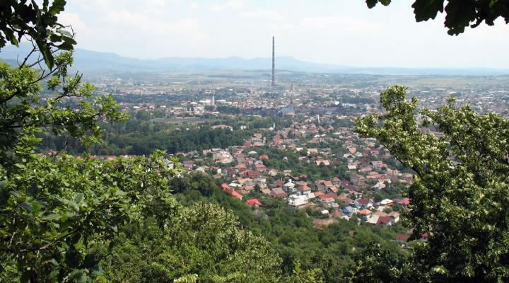
After returning to the traditional administration formula of the Counties (1968), the Maramures county with the current organizational structure was established, by including in its area of settlements the valleys of Maramures, Baia Mare, Lapus and Chioar, as well as some of the valleys of Somes and Sălaj. Thus, the term "Maramures" began to define another administrative reality than before. The county residency became Baia Mare, a city attested in 1329 which had a spectacular evolution, both demographically (from 14,000 residents in 1930 to about 140,000 today) and economically, being an important center in this part of the country, with a specifically dynamic development.
Tourist objectives
Vaser Valley – Narrow Gauge Railway Train “Mocanita”
 Vaser Valley – with central points of interest such Viseu de Sus and Mocăniţa, is one of the main tourist attractions in Maramures, having a tradition in tourism dating back to the twentieth century. The area enjoys a picturesque unpolluted natural setting, with spectacular landforms than can be exploited in tourism for rest and relaxation, hiking, climbing, scientific interest, but also having offering many possibilities for leisure and relaxation.
One of the most important cultural and technical values of the country, the Narrow Gauge Railway Train “Mocanita” from Viseu de Sus is the last steam train used for timber production in the world. Built as a more practical technical solution for transporting wood, the railway is still in use, for the initial purpose, but also for tourism.
Iza Valley
 Iza Valley is an area that has kept more traditions than any other Romanian region. The area gathers under the same name, which is not given by the river that crosses the zone, but by the former administration of the territory– "Knyaz ruling of the Valley" – several settlements where people’s way of clothing and traditions are similar; this leads to a uniform ethno-cultural space.
Visited mostly for the traditional wooden gates, the local traditions and clothing, natural landscapes and welcoming people, The Iza Valley is an attraction by itself.
Churches and monasteries
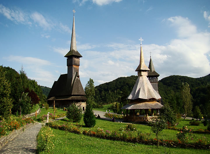 Outstanding examples of Romanian architecture and sources of spirituality, the churches and monasteries from Maramures are some of the most important attractions of the county, eight of which were included in 1999, in UNESCO: the wooden churches from Budeşti, Deseşti, Barsana, Poienile Izei, Ieud, Surdesti, Plopiş and Rogoz.
They demonstrate a high level of artistic maturity and craft: they are narrow, high, built of logs with one or two towers characteristic of shingles roof. The walls are generally built of oak logs laid horizontally.
One of the most important cultural and technical values of the country, the Narrow Gauge Railway Train “Mocanita” from Viseu de Sus is the last steam train used for timber production in the world. Built as a more practical technical solution for transporting wood, the railway is still in use, for the initial purpose, but also for tourism.
Iza Valley
Visited mostly for the traditional wooden gates, the local traditions and clothing, natural landscapes and welcoming people, The Iza Valley is an attraction by itself.
Churches and monasteries
They demonstrate a high level of artistic maturity and craft: they are narrow, high, built of logs with one or two towers characteristic of shingles roof. The walls are generally built of oak logs laid horizontally.
The Merry Cemetery of Săpânţa
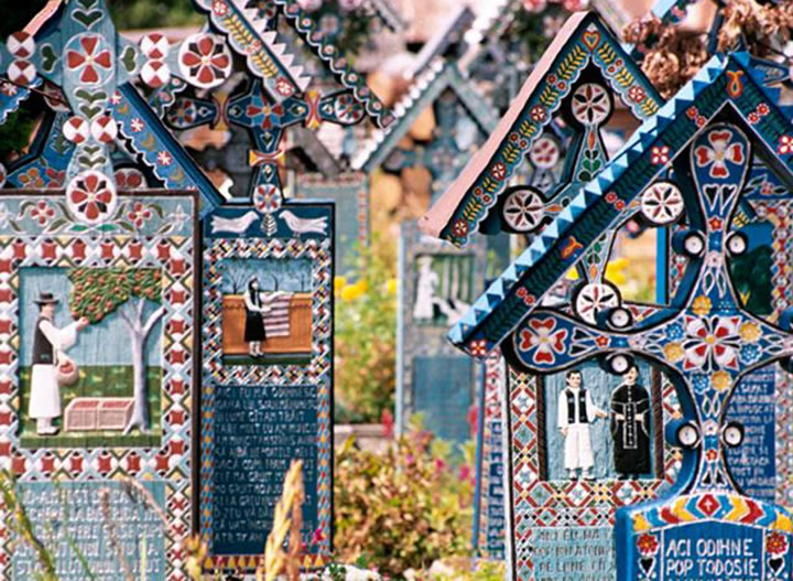 The Merry Cemetery of Săpânţa, a priceless monument of popular art and local traditions, is known for the vividly colored crosses, with paintings depicting scenes from the lives of the dead, and funny lyrics that remind of their life.
The merry cemetery dates from the middle of 1930 and is the creation of the local crafter Stan Ioan Pătraş, who was simultaneously a sculptor, painter and poet. Hes creativity transformed the place – a generally sad one – in a happy one, giving wood the colors of life and graving the crosses with lyrics inspired from reality and enriched with humor. This way, the cemetery became a wooden archive of the stories of the locals.
Sighetu Marmaţiei Memorial to the Victims of Communism and to Resistance
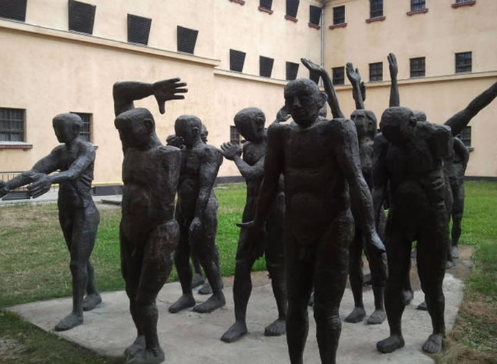 The Memorial to the Victims of Communism and to Resistance, which includes the museum in the Sighetu Marmaţiei former political prison and the International Centre of Studies on Communism, based in Bucharest, is meant to restore and to preserve the memory of the Romanian people who, throughout half a century, was taught false history.
Since 1997, the Sighet Memorial has been a national objective and, starting from 1998, it has been ranked by the Council of Europe among the first three places meant to cultivate European memory, together with the Auschwitz Memorial and the Memorial of Peace in Normandy.
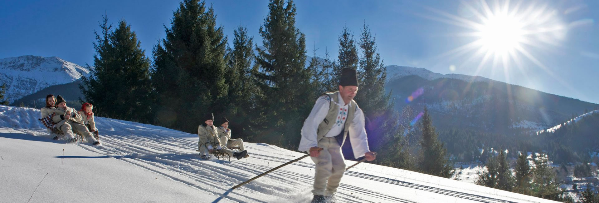
Winter Resorts
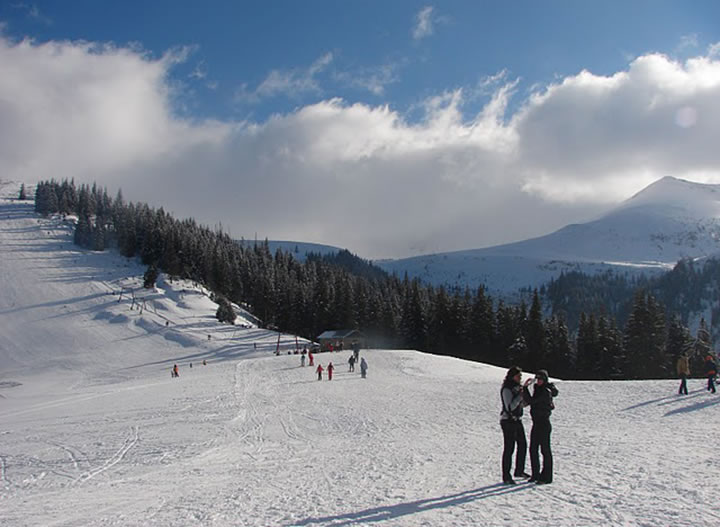 Regarding winter sports, Maramures County is an area rich in slopes with varying degrees of difficulty, located in a natural setting. The relief is predominantly mountainous and is located in the north, enjoing snow throughout the whole winter, from December to April.
Mountain ski resorts in the area are in Rodnei Mountains and the Gutai Mountains. The slopes are located at altitudes between 800 and 1500 m and are equipped with cable transport installations, some being approved for conducting national competitions. There are ski slopes in Borsa, Cavnic, Izvoare and Mogoaşa Şuior.
The merry cemetery dates from the middle of 1930 and is the creation of the local crafter Stan Ioan Pătraş, who was simultaneously a sculptor, painter and poet. Hes creativity transformed the place – a generally sad one – in a happy one, giving wood the colors of life and graving the crosses with lyrics inspired from reality and enriched with humor. This way, the cemetery became a wooden archive of the stories of the locals.
Sighetu Marmaţiei Memorial to the Victims of Communism and to Resistance
Since 1997, the Sighet Memorial has been a national objective and, starting from 1998, it has been ranked by the Council of Europe among the first three places meant to cultivate European memory, together with the Auschwitz Memorial and the Memorial of Peace in Normandy.
Winter Resorts
Mountain ski resorts in the area are in Rodnei Mountains and the Gutai Mountains. The slopes are located at altitudes between 800 and 1500 m and are equipped with cable transport installations, some being approved for conducting national competitions. There are ski slopes in Borsa, Cavnic, Izvoare and Mogoaşa Şuior.


